


Whangamomona Road is not for the faint-hearted. It slips off into the never-never from the Forgotten World Highway at Whangamomona village, tip-toes over cliff tops, sloshes through valleys, burrows under hills and meanders through mud and muck. If you make it to the end, you'll reach the ironically named Bridge to Somewhere.
We're braving the road and bouncing along on the back of a four wheel motorbike driven by Whangamomona Republic president Murt Kennard. President Murt is a man who looks like a cross between a hobbit and a bush hermit. An impressive salt and pepper beard rests on a chequered bush shirt that hides a T-shirt claiming: “Just because you're 50 doesn't mean you're f**!*!” As well as being president of the little republic he runs the Whangamomona Garage and works as a local ‘roadie’.
He's a rough and rugged character with a heart of gold. President Murt (as in Murtle the Turtle “cos I'm a slow bugger”) gives us a running commentary of the country we are entering, the Whangamomona Road and the abandoned settlement of Aotuhia. This is rugged country, broken, steep hills, narrow valleys plunging to streams flowing through deep gorges, all covered in bush and mud. Wild country that refuses to be tamed.
It's difficult to imagine, but early last century people came to farm this land. Aotuhia was one of the first settlements in the Whangamomona district - the first settlers moved in around 1896. Murt tells us of the “poor buggers” who had bought a little block of land to call their own, later, returned servicemen from World War One were balloted onto the land. They came with axes and saws to clear the country and tame it. Most were beaten, the land fighting back. Floods, slips, lack of access and the Depression ground people down and forced them to abandon their dreams. Now the land is reverting to bush. A blanket of scrub covers what was once painstakingly cut out for sheep paddocks.
In the beginning there was no road. The first settlers arrived in the area by boat, up the Whanganui River. A pack track was dug and all stores were lugged over the hill. Materials for the first house in the region and the first sheep were brought up by this method. For several years the river was the only means of transport. All produce: wool, butter, skins and hides were packed to the river and floated down stream. All goods inwards followed the same route.
A post office was set up in a local home, and a small school built to accommodate the 20 children of the district. A sports ground was cleared and regular events were held. But the river traffic was unreliable. Floods brought down logs that blocked the route. The landing site was frequently under water. If the swirling waters didn't get the stores then hordes of rats would often beat the settlers to the goods, strewing the contents over the landing.
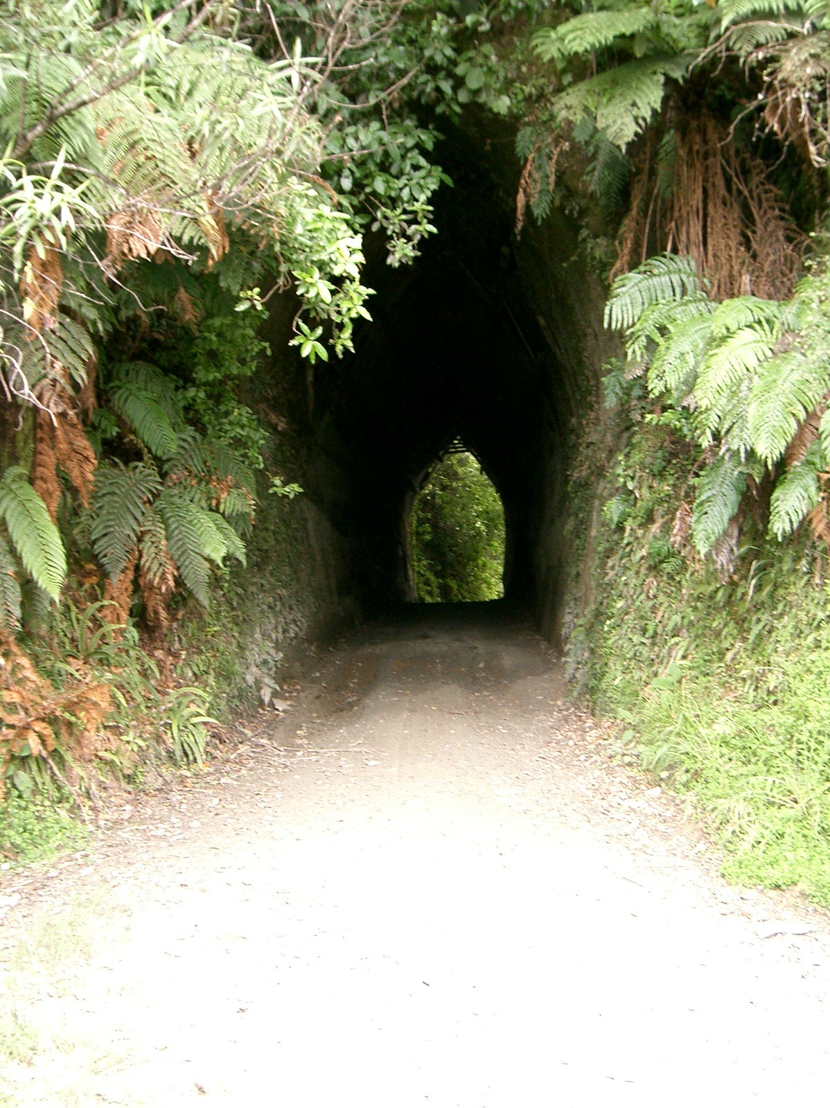
The farmers in the steadily growing little district protested and a road was built to Whangamomona - the road we are travelling now. It clings to the steep hillside, skips its way across papa bluffs and burrows under hillsides. Today it's a mess - but passable. Murt expertly manoeuvres the bike around slips and through seemingly bottomless puddles, roars through tunnels and picks his way around the messier patches. Back in the 1920s keeping the clay road passable for bullock teams was a difficult matter. In winter the worst places had to be ‘corduroyed’ with split slabs or ‘fascined’ with scrub, and even then bullocks got bogged, some even having their necks broken. In the dry weather the deep ruts dried up and became almost impossible to negotiate.
But it was a blessing for the people of Aotuhia. They now had regular access to the outside world - or at least as far as Whangamomona. "Settlers would finish work on the farm, saddle up a horse and ride out through the bush to the local dances," says Murt. "It was often the highlight of their week - a bit of social contact. They were hard b!*!*rs - imagine doing that today!"
He stops the bike near a papa sidling. High up the bank chunks of red clay peek through the blue papa - remnants of an idea by an inventive road contractor. Putting metal on the muddy roads was an expensive task. The contractor devised a more economical method of alternately stacking papa and wood then setting it alight. The resulting burnt papa was a red colour and made a great road covering. The terracotta red clay is visible all along the Whanga Road.
Despite increasing accessibility the Aotuhia settlers still suffered. World War One had carried off 70 per cent of its young men, many never to return. While the road was a blessing it was also a curse - someone had to pay for its upkeep - so rates were raised to astronomical levels. Uneconomic sections, isolation from slips across the road, fluctuating prices for stock and the 1920s depression put a gloomy cloud over life in the back blocks. As farmers left the land numbers dwindled, the school closed, and very few people remained in the district.
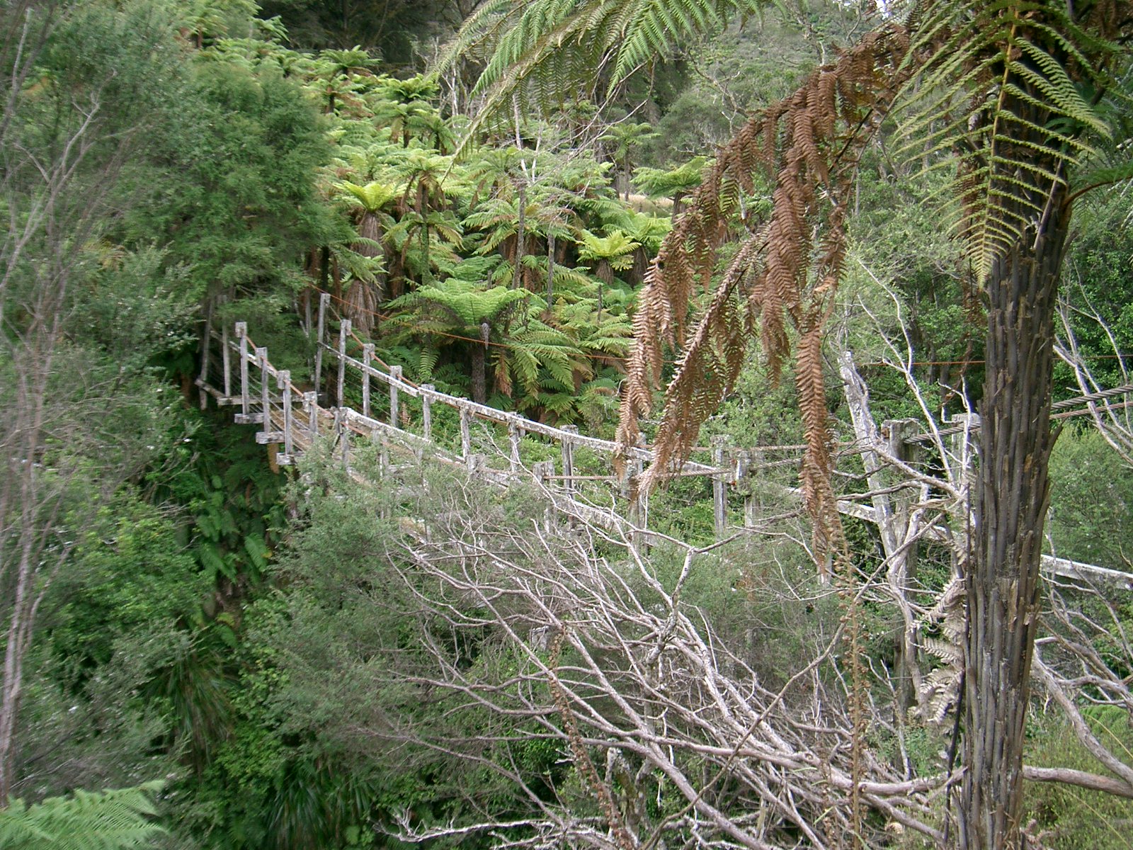
We pass a swing bridge that leads, apparently, to nowhere. Covered in lichen and scrub, missing boards and held together with rusty bolts the rickety structure spans a deep gorge and alights at what is now grassland pocked with ponga and scrub: a farm long abandoned. It was across this gorge that a husband and wife carried their worldly goods to set up home in a patch of bush in the middle of nowhere. "They began clearing the land and had four children before they left the tent to live in their house," says Murt. "In all they had 22 children!!" The small patch of scrub and gorse across the gorge looks an unlikely home for such a large family. As with many other families the land soon proved uneconomic, eventually the country got the better of them and they too departed. "It was a hard bloody life for them out here in the middle of nowhere," says Murt. "It's surprising they stayed here as long as they did."
Remnants of other settlers are few: the land has swallowed them all. Somewhere out the back are a few coal ranges, a chimney or two, but nothing to show that once a little community eked out a meagre existence here.
The bike slips its way along the road. Occasionally we leap off in fear as Murt bunny hops over slips and roars through guts. On one side of the road a papa bluff rises to the horizon, on the other the gorge falls away to the river below. It's been over 60 years since Whangamomona Road last saw a grader. In 1942, after a big storm, the government decided to close the access. The few remaining settlers either sold up and left or struggled on using the deteriorating road.
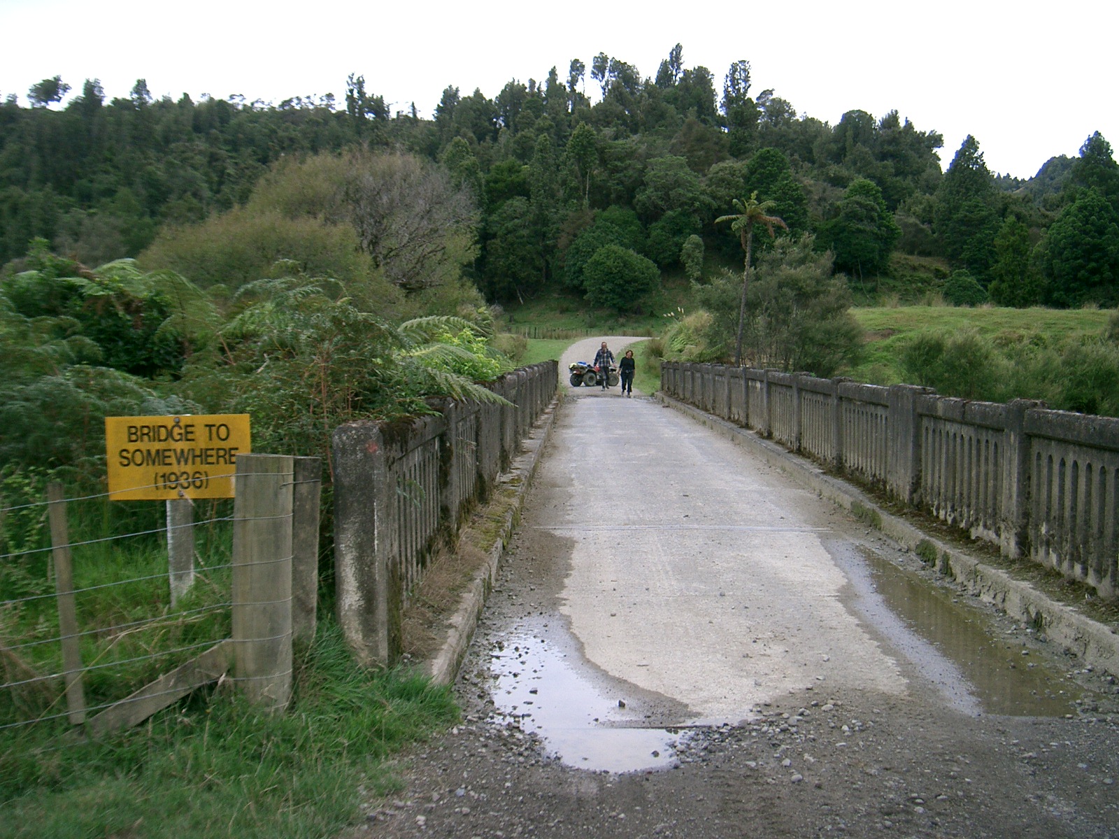
Today only the brave-hearted use Whangamomona Road. Four-wheel drive clubs, horse treks and the occasional local slip and slide their way to the Bridge to Somewhere. The bridge, a similar design to the Bridge to Nowhere, was built across the river back in 1936, ironically, too late for many of the settlers who had already left the area. Now it leads to Aotuhia Station, one of the largest farms in the district. Whangamomona Road has never been for the faint hearted. It's a trip down a road of memories, a tale of hardship and struggle against a land that didn't want to be tamed.
Church, I. (1990). The Stratford inheritance: a history of Stratford and the Whangamomona counties. Waikanae: Heritage Press
Garcia, J. (1940). History of Whangamomona County. New Plymouth: Whangamomona Centennial Celebrations Committee.
Morris, D. (2004). All for nought: the Whangamomona Road, Aotuhia, Okara Valley : the bridge to somewhere Aotuhia. Inglewood: D. Morris.
Opening of the road to Aotuhia: tour of the Stratford County hill country, organised by the Stratford County and the Dept of Land and Survey (New Plymouth) (1985). Stratford: Stratford County Council.
Please do not reproduce these images without permission from Puke Ariki.
Contact us for more information or you can order images online here.


