 Walter Bewley. Bernard Woods Studio. Copy negative. Collection of Puke Ariki (WD.016893).
Walter Bewley. Bernard Woods Studio. Copy negative. Collection of Puke Ariki (WD.016893).
Walter Bewley. Bernard Woods Studio. Copy negative. Collection of Puke Ariki (WD.016893).
Several land surveys completed in 1976 show plans for a short, no-exit road in Waiwhakaiho, to be named Bewley Road. Despite the road never being developed, it still exists on perhaps the world’s most popular map system.
Bewley Road was intended to intersect with the northern side of Devon Road, opposite the then-fertiliser works, and provide access to industrial land beside the Waiwhakaiho River. Any plans didn’t last long, however. By the mid-1980s, the development of Rifle Range Road meant Bewley Road was no longer necessary.
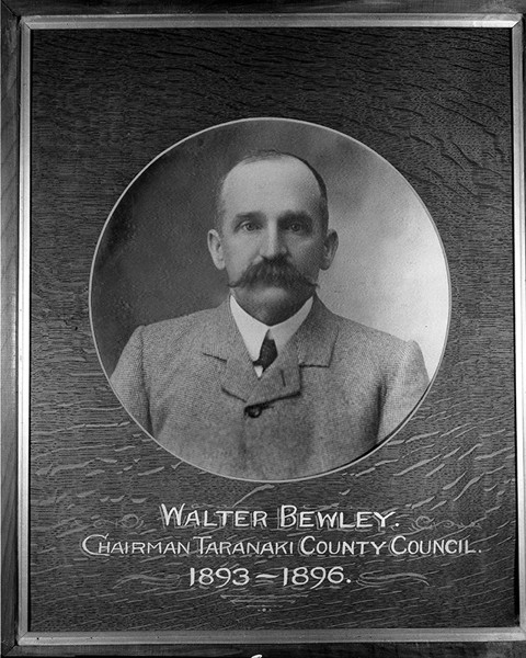
It had been named after Walter Bewley. Born in England, he settled in Taranaki and owned farmland south of Inglewood. Later he worked as a sharebroker and land agent in New Plymouth. Bewley was very active in community organisations, most notably as a chairman of the Taranaki County Council in the 1890s.
He was also a prominent local cricket player. His son, solicitor Austin Bewley, played a central role in the founding of the New Plymouth Old Boys’ cricket club in 1919.
Walter Bewley died, aged 66, in 1922. The road named after him hasn’t disappeared off every map. One of the world’s most popular, Google Maps, shows ‘Bewley Road’ in Waiwhakaiho. However, it bears no resemblance to the original plans. How it came to be on the map, and why it is in a different location, are unknown.
This story was originally published in the Taranaki Daily News.
Related plan:
Taranaki DP12248 Sheet 1 Bewley Road (1977), ICS Pre 300,000 Cadastral Plan Index (Imaged by LINZ)
Please do not reproduce these images without permission from Puke Ariki.
Contact us for more information or you can order images online here.


